
Granite Peak Montana
Granite Peak Montana
Reach Granite Peak: the high-point of Montana via a lengthy approach, consistent exposure above 10,000 feet and challenging route finding to the rocky summit.
Infamous for it’s temperamental weather we threaded the weather needle, between snow storms and were fortunate to get possibly some of the last best conditions of the season.
Trail head – 6,500’ West Rosebud trail head
Highest point – 12,799’ Summit
Cumulative Vertical Gain – 9,960′
Miles – Approx. 30 round trip (added a few stumbling around in the dark).

Granite Mountain Approach
Day 1:
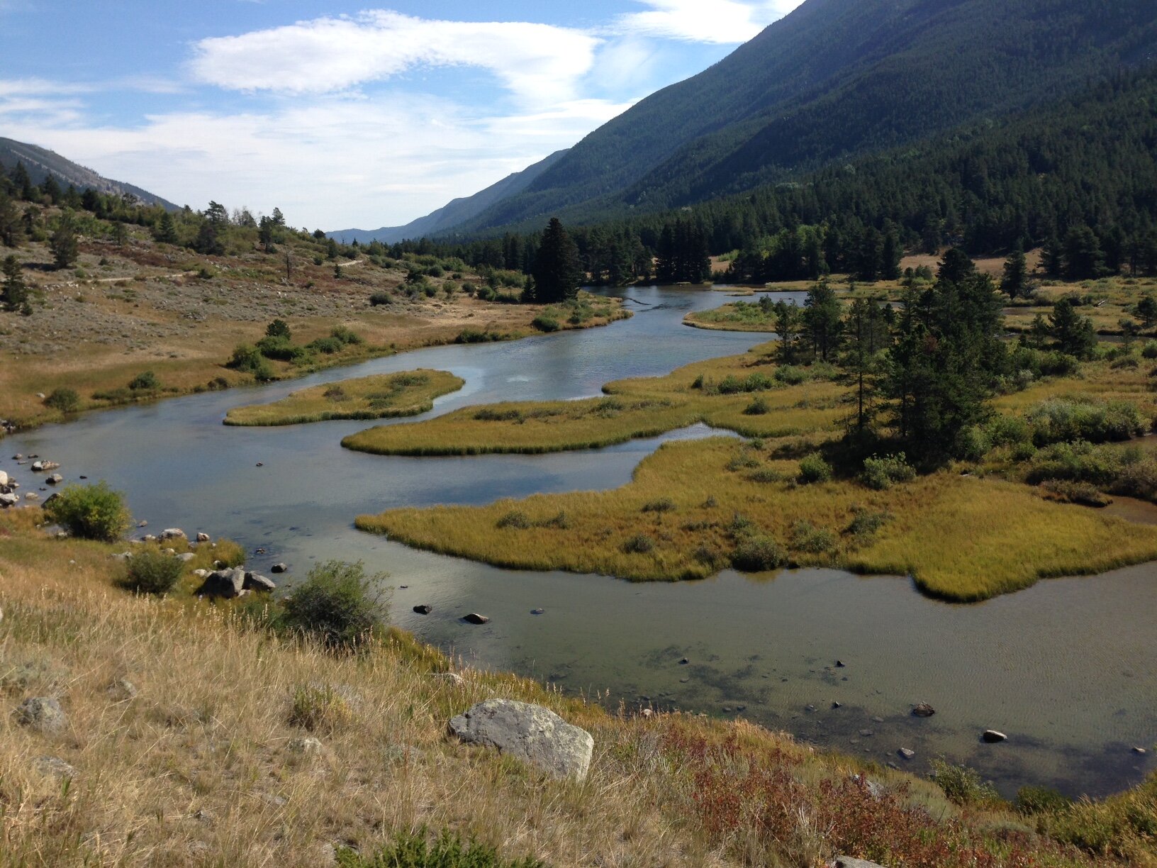
West Rosebud drainage view from Parking Area.
Driving from Bozeman and Billings respectively we met up in Columbus to shuttle cars to the West Rosebud trail head.
We started hiking from the trail head at 4:00 on Friday. In good spirits with fresh legs we made it up the first switchbacks to Mystic Lake in about an hour.

Dam at Mystic Lake
Up the next switchbacks to a camp area just below Froze to Death Plateau at 9,500′ in time for a warm dinner and set up camp before dark. No water at this lower campsite, but found some snow to melt from a snowstorm the day before that had turned back an earlier party we met on the way up.
The plan was to ditch the heavy packs and set camp above the switchbacks but below the exposed Froze to Death Plateau limiting our distance carrying heavier packs hopefully allowing us to make a quicker pace on summit day.

Camp at sunrise above Mystic Lake
Day 2:
Set the alarm for 5:30 am. After breakfast, coffee and arranging summit packs and climbing gear started hiking at 6:30 as the sun rose on Froze to Death Plateau. Navigated with help of quad map and cairns along the way. Found running water at prominent bivy spot below snowfield. Many rock-walled bivy spots along the way giving testament to the exposed area and winds that accompany it.

Cairns in Morning Light on Froze to Death Plateau
The plateau at 10,000 feet lacking a trail other than cairns and bivy spots along the way made for slower than anticipated progress rock hopping and navigating along the way. of plateau We were hoping to cover the 6 miles of Plateau at 2-3 miles an hour, but ended up averaging about half of that.

“Climbing” Section of Granite Mountain
Finally getting a glimpse of the North Face of Granite peak before crossing the last massive boulder field to descend slippery cross slope to the final “bivy” notch before the true climbing begins.
Being very careful of footing descending the traversing slope on wet rock and snow to the bivy ledge where we left our trekking poles and started climbing up the 3rd class talus to the crest of the ridge. This looked scarier from afar than it actually was. Having the good fortune of a party hours a head of us we were able to follow boot prints in the snow scrambling through the blocky ridge.
At the crest there is a great view of the snow bridge and first rock pitches, now the technical part of the climbing route. We were able to observe another party on the second pitch, again much scarier to watch from afar than actually climb. After crossing the exposed snow bridge (may need ice axes earlier in the season) we roped up, scrambled down and I climbed to the first set of anchors.

Belay/Rappel Stance above snow bridge
A rope team of 3 isn’t ideal from an efficiency stand point but we worked as well as we could pitching out short chimney sections (mostly rated low 5th class) broken up with simul-climbing 3rd class up through what I call the “cat ears” then back down again to the next short chimney pitch followed by another down climb to reach the upper section of rock pitches and scrambles.
The upper mountain was longer and had more ups and downs than I anticipated from reading route descriptions.
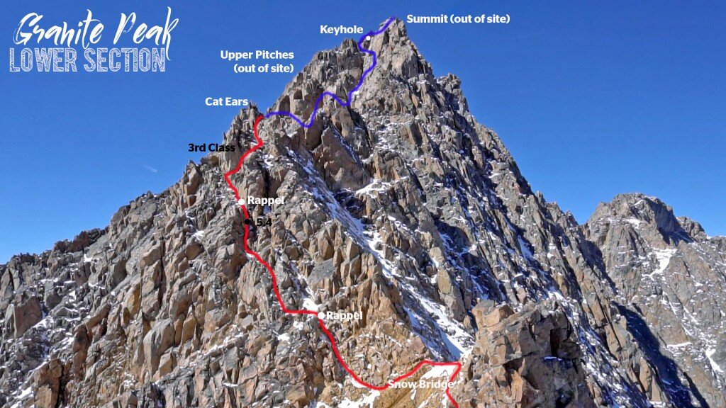
Granite Peak snowbridge and Lower Pitches
A few more 5.4 pitches (one with an overhang) and a traverse to the left under the keyhole let to the last belay stance.

Pulling up around the corner I was relieved to see easy blocky slabs leading to the ledgy summit. Summited at 4:20, 5 hours later than our initial plan. We spend a few minutes at top before heading down and helping the other climbing party with a stuck rope a couple of times. Counted 7 rappels and some class 3 down climbing back to the snow bridge. The sky started filling with smoke from fires in the Tetons in Wyoming.

By dark we were on our way back up to the plateau. Spent the next 6 hours navigating the 6 miles across the plateau in the dark with the help of topo map and iphone GPS app topo maps to help us solidify our position. Made it back to where we thought the tent should be by mid night but couldn’t locate it in cliffy terrain, so we were able to continue further down where we eventually met the trail above the switch backs and were able to re-trace our steps to find the tent by 2am. Much relieved to have shelter and a warm place to get a few hours of shut eye before the final 6 miles out on trail.
Granite Peak Summit Panorama
Day 3:

Happy Hikers David and Corey
Slept in until 7 or so, had some coffee and remaining bars for breakfast while packing up the tent and gear. Enjoyed a pleasant hike out dropping elevation and feeling the warmer oxygen rich lower elevations in the woods around mystic lake where we were able to replenish our water in a stream on the way. Made it back to the car at the trail head by 10am Sunday Morning.
Cleaned up and headed straight for bacon eggs and coffee at the diner in Absorkee.
Gear:
• 60 meter rope
• Set of wired nuts
• half a dozen slings
• anchor webbing
• Ice Axes (didn’t use)
• Traction Devices (didn’t use)

Summit Marker